So you are looking for a handheld GPS for hunting? With all the technology available today, handheld electronic devices are becoming more popular than ever before. This guide will show you what features to look for in a handheld GPS device, so you get the best bang for your buck. Plus, we will talk about different models and their individual benefits or cons.
In case you’re in a hurry and are just looking for our recommendations, without any further due:
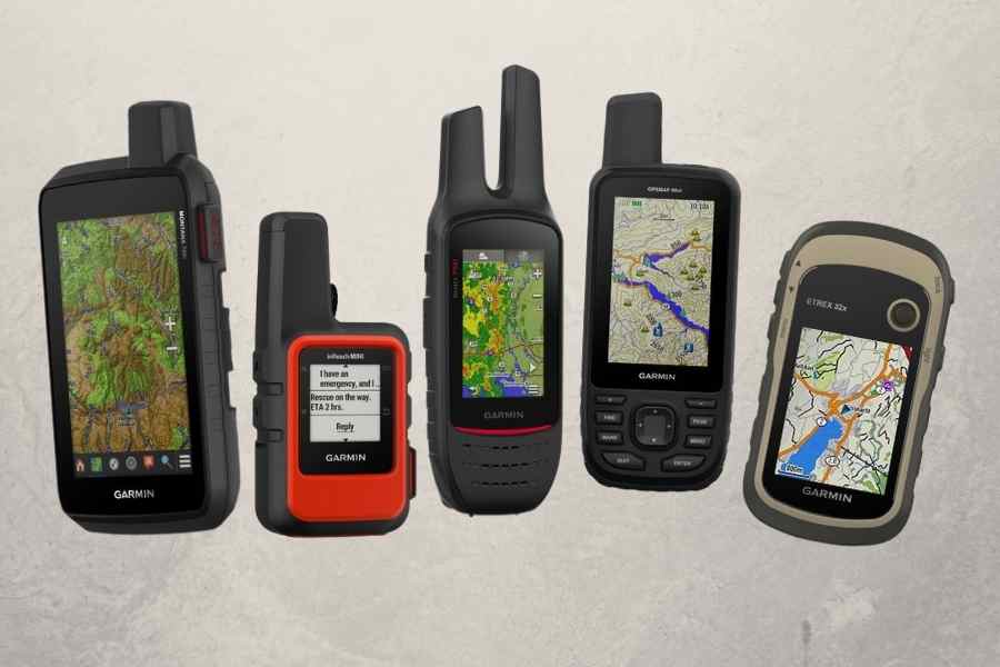
Here are our top 5 recommended handheld GPS Unit
+ BEST OVERALL – Garmin GPSMAP 66st. The 66 series is available in different versions. The 66st comes preloaded with TopoActive Maps, Built-In Barometric Altimeter, and Compass. Supports GPS, GLONASS, and Galileo.
___________________
+ GPS WITH WALKIE-TALKIE – Garmin Rino 750. Features a walkie-talkie function with a range of up to 20 miles. GPS and GLONASS reception, preloaded TOPO mapping.
___________________
+ MICRO SD CARD SLOT – Garmin eTrex 32x. Preloaded Topo Active Maps, supports GPS and GLONASS, 3-axis compass, altimeter.
___________________
+ GLOVE-FRIENDLY TOUCHSCREEN – Garmin Montana 700i. The 5″ Display Size Touchscreen of the 700i is 50% larger than its previous model. Rugged design, Two-Way Messaging SOS Function via Iridium Satellite available.
___________________
+ EASIEST TO CARRY – Garmin InReach Mini. 90 hours battery life. SOS 2-way text messaging via Iridium Network available. Connect with your smartphone and access downloadable maps via free Garmin Earthmate app.
___________________
+ HUNTING MAPS for GARMIN GPS – ONX Mapping Solution. Public & Private Land, color-coded. See the landowner names and property boundaries. Available for 35+ states!
We talk about the pros and cons of each device further done below in the buyers guide section. Click here!
Contents (Jump to Topic)
ToggleHow to Choose the Best Handheld Unit for hunting?
Before you start shopping, you need to know what features you want in your GPS device. There are several features that you should consider at a minimum. The most important features to look for are the following:
1. “Waterproof” rating
This is a must-have for any handheld GPS device you plan on using while hunting. It is also a good idea to choose one that can float if possible. Most high-quality residential grade handhelds range from IPX7-8 waterproofing, which can be submerged in water up to 3 feet deep.
2. Durability
Sometimes it can get tricky – You want a GPS that can hold up. For around $150, you should be able to find a rugged handheld GPS that is shock-resistant and impact-resistant. If you have to carry your GPS device in the woods, you want a GPS that will stay with you.
3. Size & Weight
Most handheld devices are small enough to fit in a pocket, or if it is too big for your pocket, it should be okay to wear it on your belt or shoulder strap instead. Consider exactly how much space and weight your chosen handhelds will take up. You don’t want to end up with a device that is too large for your needs.
4. Battery Life
Battery life is critical. While there are many ways to get around this problem, one of the best options available today is the rechargeable “Lithium-ion” batteries found in most high-end handheld GPS models. Depending on the number of features you’ll be using and how often you’ll be using them, you’ll want a minimum of 15 hours of battery life on a single charge from your handheld GPS device.
Devices that allow you to change batteries are preferable – Bring an extra pack of batteries, and you are good to go.
5. Touch Screen vs. Buttons
Touch screens are nice, but with your gloves on, entering coordinates can become tedious. Buttons are always more reliable than touch screens and faster to use because you don’t have to look down at the screen every time you want to change something.
6. Satellite Reception & Accuracy
In addition to the accuracy, the number of satellites used by your GPS device will affect its speed. At least 12 different satellites should be used by your GPS hunting device. You should ideally have 24, as the US Department of Defense has. Good hunting devices will use at least 12 of these satellites to ensure good satellite signals.
Modern GPS devices offer WAAS (Wide Area Augmentation System) to improve the accuracy of their position information. The WAAS feature allows for an accuracy of 3-8 meters.
7. Speed
The processing speed of your GPS device will affect how fast it calculates routes, tracks your location and how quickly it responds to your changes. When you need to get somewhere quickly or calculate many waypoints, having a fast processor is vital.
8. Mapping Software
Most handheld GPSs come with maps already built-in, but if you want expanded map coverage or your device does not have maps, it can get pricey as each map download may cost as much as $40-$200+ depending on the area in which you hunt and what device you are using.
Topo Maps: You will need to access topographical maps of your area to be aware of all the land features around you. Topographical maps are also helpful for scouting for different locations and routes, so make sure the handheld GPS device you purchase has this critical feature included.
9. Internal Compass
While the internal compass feature isn’t as crucial as it was during the days of paper maps, having your GPS indicate which direction you are facing is still invaluable when you are hunting. This feature will also help you get a feel for where your target may be located.
10. Internal Memory
“Outdoor and Marine handhelds have reserved internal memory for data, such as waypoints, routes, tracks, activities and geocaches.” So there is a certain limit! Make sure your device has sufficient internal memory reserves.
Source: https://support.garmin.com/en-US/?faq=rFMnK0E1GOAC7SG3rGhV0A
But to be fair, if you look at the GPSMAP 64 Series, for example, the limits are almost impossible to reach. We are talking 5,000 waypoints, 200 routes, 250 points per route, 2,000 GPX files, …
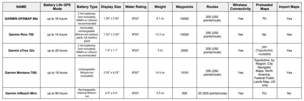
GPS Comparison Table

Why do Hunters need a Handheld GPS?
Hunters need it primarily for marking spots and scouting. Using a handheld device for hunting is as simple as marking important waypoints and navigating to treestands in lousy light conditions using GPS. When using a handheld GPS, there is little need to light the forest with a flashlight. Another benefit is that you will not expose your location to other hunters so easily. Let’s say you found the perfect tree for saddle hunting – mark the spot in your GPS for your next hunting trips.
What is the easiest GPS to use for Hunting?
One of the most straightforward hunting GPS units to use is the Garmin GPSMAP series. Its simple menu and the fact that it does not have a touchscreen allow you to use it even with gloves. And the color-coded public land maps from the Hunt Chip are easy to read on its 3″ screen.
How long should a handheld GPS for hunting last?
If you are talking about battery life, you should look for 12+ hours in GPS mode and a much longer mapping mode. Don’t forget to bring spare AA batteries!
If you are talking about lifetime: most manufacturers offer a 1-Year warranty. But that doesn’t mean that your GPS won’t last much longer. If you read through various forums, it’s not uncommon that a handheld device lasts 10 years and more.
To make your GPS future-proof, there are a few things to consider before you are buying one.
Features to Have
- Sunrise/sunset table
- Uploadable topographic maps
- Backup function
- Micro SD card slot
A history of handheld GPS Technology
The Global Positioning System (GPS) was developed by the US military in 1978. Ronald Reagan announced after the Korean Airline disaster in 1983 that GPS was to be made available for public usage. In the 90s, GPS signals were graded, and it was not until 2000 that President Clinton granted civilians access to un-graded GPS signals. Then in 2007, President Bush made that commitment permanent.
Source: https://odimpact.org/case-united-states-opening-gps-data-for-civilian-use.html
The first handheld GPS was introduced to the market in 1989. It was the company Magellan that introduced a device called “NAV 1000”.
Who pays for the GPS system?
The American taxpayer pays for the GPS service enjoyed throughout the world. The yearly costs are 750 million. $12 billion were the costs to put the system into orbit.
Source: https://www.gps.gov/policy/funding/
Do you need a handheld GPS for Hunting?
Do you need one? Nope. Will it make your life easier in the woods? Absolutely! It will make your life easier, especially if you have to hunt in adverse conditions. In such cases, even being able to mark your location can make all the difference. Your GPS will also help you figure out how far you are from your treestand, the water jug, other treestands around, and if you’re on public or private land.
There are a lot of places that sell handheld GPS devices. There are also plenty of local and national businesses that sell hunting GPS units. You can even look at sites like eBay or Craigslist for a used or refurbished handheld GPS unit.
What are the benefits of using GPS?
A handheld device serves many purposes, including navigation, timekeeping, and keeping track of your location.
What is the best handheld GPS for hunting?
The best hunting GPS may be the one that fits your needs and style of hunting, but in general: you want a dedicated handheld device, not a smartphone, unless you are just using it for marking waypoints.
You want an accurate GPS with a big screen and good battery life. If you’re hunting in a forested area where the treestands are far away from one another, then a GPS unit can be your best friend.
Additionally, it allows you to distinguish between public and private lands by color-coding boundaries so you will know which areas you can hunt on. Nobody likes ending up on private land without asking the owner first.
Another benefit is that you can easily mark important waypoints.
- game trails crossing
- bedding areas
- water sources
- buck rubs
- your treestands
- perfect hunting location
- shows your exact location
- tree for saddle hunting
- your car (!)
A GPS could also be beneficial if you are hunting in an area new to you. You can use the function of an electronic breadcrumb trail to mark your steps. Then, if you get lost, you can find your way back through the breadcrumbs and follow your route. And if you decide to go for a touchscreen display, make sure it’s “gloves-friendly”.
How Do I load Maps onto my Handheld GPS?
There are several ways to load maps into your device when using it for hunting. The simplest way is to use a microSD card and plug it into your GPS. This requires that you download your map information ahead of time. For extra maps, check out HUNTING MAPS for GARMIN GPS.
Garmin GPSMAP 66s

GARMIN GPSMAP 66s
Do you want to find your way quickly and easily? Then look no further than the Garmin GPSMap 66s. If you’re looking for a portable navigation tool that will help you get where you need to go, then check out the Garmin GPSMap 66s. Its rugged design and up to 10,000 waypoints make navigating easier than ever before.
The GPSMAP Series
The GPSMAP 66s is one of the available models out of the GPSMAP series. I found it to be the model that offers an ideal price point while still offering great features. Here is an overview of the different GPSMAP models I found ideal for most hunting situations.
GPSMAP Outdoor devices
- GPSMAP 66 series (66i, 66s, 66st, 66sr)*
- GPSMAP 65 series (65, 65s)*
- GPSMAP 64 series (64x, 64sx, 64csx)*
*a click on the link directs you to the merchants’ page.
It’s easy to see how the model line evolved from the 5,000 waypoints the 64 and 65 series offered to the 10,000 waypoints the 66 series offers. Furthermore, the GSMAP 65 and 66sr come with pre-installed federal land boundaries and a slightly larger screen.
While the 64 series only has 8 GB of built-in memory, you could always expand it with a microSD card up to 32 GB. But the 66s has 16 GB already, plus you can get a data card too.
How To Keep on Track
Track setting on the GPSMAP series is pretty much the same for most models. Here is an explanatory video that shows you how to do that.
Link: GARMIN 66s Manual
The operating temperature range is from -4° to 113°F. Wireless frequency/protocol 2.4 GHz @ 14.9 dBm nominal. A rugged multi-satellite GPS that connects seamlessly to your smartphone. The BirdsEye Satellite Imagery is available without a subscription.
Update: TOPO maps were not included, but it seems like this change. Now it looks like TOPO U.S. and Canada maps are included too.
GARMIN 66s List of Features & Benefits:
- ABC (altimeter, barometer and compass)
- live tracking
- custom POIs
- custom maps compatible
- wireless compatibility
Pros:
- GPS, GLONASS, Galileo Satellite Network
- BirdsEye direct to device (subscription free)
- rechargeable battery pack
- digital compass
- Buttons
Cons:
- no camera
read.. film your hunt camera guide
Garmin Rino 750

GARMIN Rino 750
The Rino Series
The Rino 750 is one of the available models out of the Rino series. A great price point and great features make this the perfect model. Below are the different Rino models I found ideal for most hunting situations. The 2-way radio function makes it easy to contact your hunting buddies. The range was extended up to 20 miles.
Rino Outdoor devices
*a click on the link directs you to the merchants’ page.
Both the 700 and 750 don’t come with maps preinstalled. There’s more internal memory and an 8-megapixel camera on the 755t. The Rino 700 isn’t for me. You can’t add maps, only have 1000 waypoints and no POIs! I recommend the 750 because it’s almost $200 cheaper than the 755t. Get the most bang for your buck!
| Garmin Rino 700 | Garmin Rino 750 | Garmin Rino 750t | |
| Preloaded maps | no | no | yes |
| Can add maps | no | yes | yes |
| Can use a microSD card | no | yes | yes |
| Waypoints/routes | 1000/50 | 10,000/250 | 20,000/250 |
| Custom POIs | no | yes | yes |
| Electronic compass | no | yes | yes |
| Garmin connect | no | yes | yes |
| Batteries | internal | removable | removable |
| check price | check price | check price |
Rino 750 Features & Benefits:
- automatic routing
- custom POIs
- custom maps compatible
- wireless compatibility
- vibration alert (!)
Pros:
- 2-way radio
- GPS & GLONASS
- Easy to find other Rino user
- Dual battery system (you can bring extra batteries)
- Color display
Cons:
- Touchscreen
- No preloaded maps
- Shorter Battery Life than the other models on our list
Garmin eTrex 32x

GARMIN eTrex 32x
The eTrex Series
eTrex 32x is the newest model in the eTrex series. The 22x and 32x come with preinstalled maps (TopoActive), and you can add your own. The eTrex 10 only has basemaps, and you can’t add SD cards to expand the memory.
The eTrex 10 is a model with rudimentary functions at a very affordable price. Custom POIs are available, and if that’s all you want, no problem. However, the 32x is a great GPS if you need a few additional features.
eTrex Outdoor devices
*a click on the link directs you to the merchants’ page.
Both the 32x and 22x come with preloaded maps (Topographic Map), and both allow you to add your own. The main difference is that the 32 comes with an electronic compass, barometric altimeter, and custom maps. GLONASS and GPS are on all three models.
| eTrex 10 | eTrex 22x | eTrex 32x | |
| Preloaded maps | no | yes | yes |
| Can add maps | no | yes | yes |
| Can use a microSD card | no | yes | yes |
| Waypoints/routes | 1000/50 | 2,000/200 | 2,000/200 |
| Custom POIs | yes | yes | yes |
| Electronic compass | no | no | yes |
| Garmin connect | no | no | no |
| Batteries | internal | removable | removable |
| check price | check price | check price |
eTrex 32x Features & Benefits:
- custom POIs
- ability to add maps
- wireless compatibility (ANT+)
Pros:
- microSD card slot
- GPS & GLONASS
- 3-axis compass
- Preloaded TOPO Maps
- Custom Maps compatible
Cons:
- No Garmin Connect
- Build in Memory is only 8GB, if you add custom maps you´ll need an microSD card
read.. trail camera Spypoint
Garmin Montana 700i

GARMIN Montana 700i
The Montana Series
The 700i is a top-notch GPS. The 750i has an 8-megapixel camera, but that’s the only difference with the more moderately priced 700i. All three Montana models are high-end devices. Do I need an integrated camera? I don’t know about you, but I’d rather take pics with my phone and save a few bucks.
It’s designed to meet MIL-STD 810 for thermal, shock, water, and vibration. If you don’t know what MIL-STD 810 is, it’s a U.S. Military Standard. You can find out more here.
Montana Outdoor devices
*a click on the link directs you to the merchants’ page.
All three models have a glove-friendly touchscreen, plus TopoActive and Federal Public Lands maps! You can connect all three to Garmin Explore – you can manage waypoints, routes, etc.
| Montana 700 | Montana 700i | Montana 750i | |
| Preloaded maps | yes | yes | yes |
| Can add maps | yes | yes | yes |
| Can use a microSD card | yes | yes | yes |
| Waypoints/routes | 10,000/250 | 10,000/250 | 10,000/250 |
| BirdsEye Satellite Imagery | yes | yes | yes |
| Custom POIs | yes | yes | yes |
| Interactive SOS | no | yes | yes |
| Camera | no | no | yes |
| Electronic compass | yes | yes | yes |
| Garmin connect | yes | yes | yes |
| Battery pack | removable | removable | removable |
| check price | check price | check price |
Montana 700i Features & Benefits:
- rugged, military grade construction
- ability to add maps
- wireless compatibility
- automatic routing
- interactive SOS function
Pros:
- microSD card slot
- Interactive SOS
- 5″ touchscreen
- Preloaded TOPO Maps
- Federal Public Lands maps
Cons:
- Touchscreen
- Battery life seems insufficient
Garmin InReach Mini

GARMIN InReach Mini
The Garmin InReach mini GPS is a durable and compact iridium satellite-based personal locator beacon that can be used to send messages, track your location, or even call for help. You can easily connect it with your smartphone or other Garmin devices for more usability.
It’s small enough to fit in the palm of your hand yet powerful enough to provide accurate position information.
The inReach Mini is tough (MIL-STD-810F) and water-resistant to IPX7 class. The device’s lithium battery can last up to 50 hours in the 10-minute tracking mode by default and for up to 20 days in the power-saving mode. Depending on the settings, the battery life varies. Charging can be done via a micro USB cable or the 12-volt in-vehicle charger. The InReach is the perfect backcountry communications device.
Pros:
- impressive battery life
- lightweight
- Satellite communicator
- Interactive SOS
- easy to connect with your smartphone or Garmin device
Cons:
- can´t import maps
- internal batteries
Hunting Maps

onXmaps
In case you are looking for a premium mapping solution for your Garmin device – Look no further but check out the hunting maps offered by ONXMAPS.
- Land ownership
- color-coded public and private lands
- names of the owners
- roads
- water data
- POIs
- Game management or hunting units
- back-roads
- trail systems
- hunter access program
- and more …
Available for phone, tablet, computer. Compatible with most Garmin devices. You do need a slot for Micro-SD or standard SD and a color screen for the color-coded maps.
Summary
There are a lot of GPS devices out there. Garmin is the industry leader when it comes to outdoor navigation solutions. You can get great features at an affordable price. Their handheld GPS devices are easy to use and very intuitive. I would recommend them for hunters who want to navigate their surroundings without a big hassle. In my opinion, Garmin offers excellent value for money.


